Published August 9, 2010
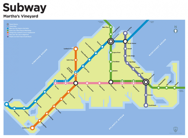
The designer Rob Stewart imagined subway lines in places without public transit and then mapped his creations, such as this one for Martha's Vineyard.
It can be a nightmare to get around Martha’s Vineyard by car. You could rent a scooter or ride a bike. But why not take the subway? Just take the Blue Line to Oak Bluffs.
OK, there’s no T on the Vineyard, and the islanders would probably keep it that way. But it’s nice to dream, isn’t it?
Rob Stewart, half of the Northampton design firm Rob & Damia, dreamed up subway lines in places without robust public transit. Imagine a line from Plymouth to P-town. Or one straight to UMass Amherst. Stewart maps these fantasy subway lines for a project called Transit Authority Figures. They’re beautiful and believable.
“I found myself staring at a T map and just thinking about how that classic subway diagram … works for every mass transit system in the world,” Stewart told me on the phone. “You could just put any names on the stops. You could just relocate it to any place, and all of a sudden that place, no matter how rural or how unadaptable … to a subway, if you just design the map, it’s completely believable.”
[pullquote author=”Rob Stewart”]”You could just put any names on the stops. You could just relocate it to any place, and all of a sudden that place, no matter how rural … it’s completely believable.”[/pullquote]
Since Stewart designed his first map for Northampton/Amherst, he has been inundated with requests from people in other towns. It has turned into a side business for the pair, selling posters and T-shirts. Stewart said he has been approached by a publisher for a book deal.
I’m reminded of a tweet I posted a long time ago, fantasizing about a “purple line” from Mattapan in the south, through Forest Hills in JP, through Coolidge Corner in Brookline and terminating in Harvard Square. Fellow Twitterers responded with even better ideas, and one person alerted me to the MBTA’s long-planned Urban Ring Project, which would connect Boston, Brookline, Cambridge, Chelsea, Everett, Medford and Somerville by bus.
Here’s my question for you, readers: What public transit options do you wish for? What’s your dream subway line? I’d love a bus from Harvard to BU. Let’s brainstorm in the comments.
Update: I talked about this Monday on Radio Boston.