|
Home > Last Stand > The View from Space
Conservation experts say President Ravalomanana will have trouble making good on his promise to triple protected land within the next five years. But even if his goal is achieved, a much more daunting task is to protect these parks, so that they are more than just green patches on the map.
Luke Dollar, a graduate student at Duke University and his graduate advisor Stuart Pimm are using satellite photos of parks in Madagascar to see if their boundaries are being respected.
Dollar and Pimm compared satellite images of seven parks over periods ranging between six and ten years. What they found was that officially protected forested land was lost at rates of between 0.1 percent and 1.81 percent per year. If clearing continues at the latter rate (the loss at the Ankarafantsika National Park during a ten-year period starting in 1989), Madagascar 's forests won't have many years left. Dollar believes the land was cleared for the same reason forest is cleared all over Madagascar: to make room for agriculture and grazing. He says to be effective park management must be located near the protected land. Until recently, Ankarafantsika park headquarters was about 70 miles away from the park itself.
In parks like Ranomafana, where the surrounding population has profited from ecotourism and other economic benefits of an intact forest, Dollar found less clearing of forest -- cutting there was only 0.52 percent annually during the '90s.
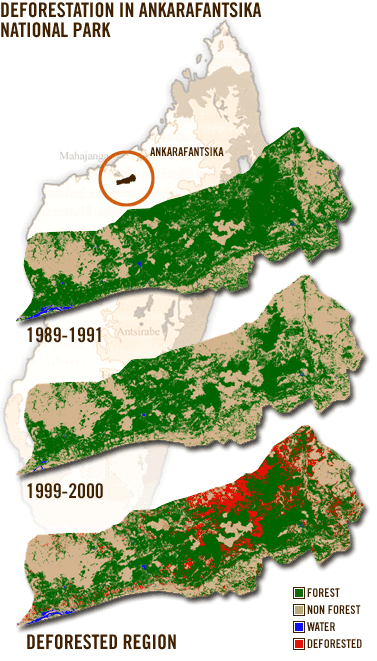
PHOTO CAPTION:
The Ankarafantsika park, Madagascar's largest
protected dry forest reserve. The top image is a composite of images taken
between April 1989 and May 1991. The middle image is a composite of images taken
between September 1999 and September 2000. The areas colored green are
forest, the tan areas are non-forest (primarily grassland) and the small
areas colored blue are bodies of water. In the bottom image, the difference between top
and middle images (forest that was cleared between 1989 and 1999) appears in red.
In
approximately one decade Ankarafantsika lost 71 square miles of forest, an
area more than twice the size of Manhattan, or 20 percent of the park's
earlier forest cover.
|
|
|